
00 // Member Build
Facility survey that keeps working when the network doesn't.
RAPID-SURVEY is an offline facility-survey and site-intelligence platform for security integrators, facilities and AEC teams, insurers, public-safety and defense customers. It runs on one field laptop, sends the heavy AI to an on-site NVIDIA DGX Spark instead of a vendor cloud, and a single CUI lockdown switch refuses every cloud call. Doors, photos, blueprints, building footprints and routes come out as AutoCAD DXF, GeoPackage, KML and Cursor-on-Target for ATAK.
- 1field laptop
- 0cloud calls under CUI lockdown
- 56requirements traced to code
- DWG + IFCAutoCAD and Revit outputs
01 // Field Demo
Shown working, not on slides.
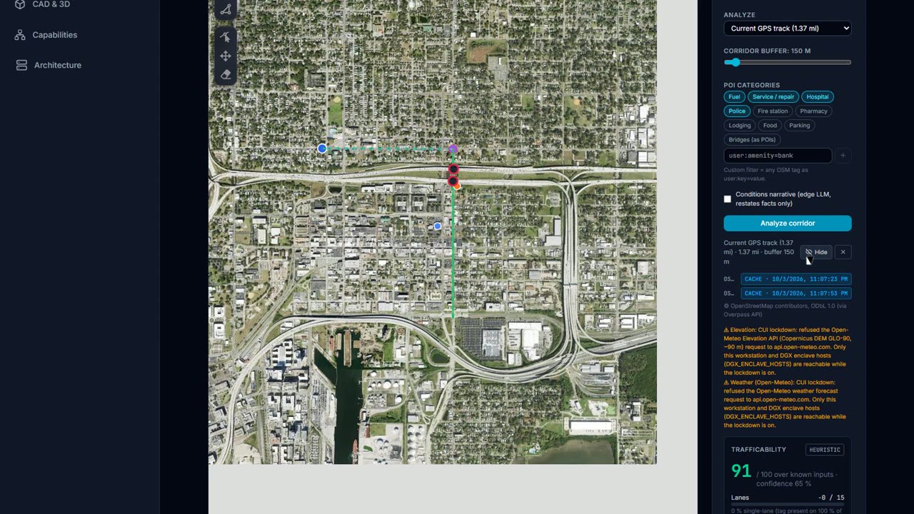
What the demo walks through
- 01Requirement knowledge graph: all 56 baseline facility-survey requirements traced to the code that meets them, gaps marked honestly.
- 02Survey-area package: Tampa roads, buildings, POIs, weather, elevation and imagery prestaged into one sha256-verified file and installed.
- 03Route intelligence under CUI lockdown, from cache only: services nearby, two I-4 overpasses, road profile, trafficability over known inputs.
- 04DGX out of reach: a 3B model on the laptop turns a dictated sentence into a door record; anything not said is dropped.
- 05Photo → CAD: an iPhone photo becomes a geolocated, heading-rotated icon in DXF and DWG; OSM footprints become a site plan and 3D massing.
- 06Autodesk package: one ZIP of native DWG drawings (NCS layers, title sheet), IFC for Revit and a MASTER.scr that overlays everything in AutoCAD.
The narration is a local, on-device synthetic voice. All data shown is public sample material. Captions are included; the video downloads only when you press play.
02 // Capabilities
What it does today, labelled honestly.
Every card carries the same status the app's knowledge graph assigns. Real runs end to end on real inputs. Partial works with stated limits. Simulated is a scripted demo and is badged that way in the app.
-
Real
Edge AI + CUI lockdown
An on-site NVIDIA DGX Spark serves an OpenAI-compatible LLM gateway (vLLM), vision (SAM 2.1, Florence-2, Depth Anything V2, VTracer) and CAD inspection, with live capability probes and a circuit breaker. One switch refuses all cloud egress; only loopback and attested enclave hosts stay reachable. When the DGX is out of reach, Ollama on the laptop takes over (qwen2.5 3B tested), and every AI value is checked against what the surveyor actually said.
DGX LLM verified live; vision and CAD clients need a tunneled endpoint.
-
Partial
Doors & security devices → AutoCAD blocks
Guided Photo → Measure → Hardware → Data plate → Review flow with an 8-minute per-door timer. Every field accepts Unknown and records its source and confidence; AI never overwrites surveyor values. Exports CSV, DXF or DWG with DOOR_TAG / SEC_DEVICE attribute blocks, and IFC door objects for Revit.
Photo dimensions are estimates (tape-confirm for ≤ ¼ in). Blocks form a schedule grid, not placed on the plan.
-
Real
Offline blueprint vectorizing → DXF
Scanned floor plans are traced on the device in a Web Worker (Otsu / adaptive threshold, two-point scale calibration) and written as LWPOLYLINE DXF. No AI and no network. A Mexico City embassy layer scan produced 1,394 closed polylines.
Traces the outlines of ink, not centerlines.
-
Real
Photo → CAD package
One ZIP: a DXF with a geolocated PHOTO_ICON block per photo at its EXIF GPS position, rotated to its compass heading and hyperlinked to the photo; photos renamed [Building]_[Floor]_[Index]; plus GeoJSON, KML and a CSV manifest.
Safety-equipment detection is not built; the SAFETY attribute is entered by hand.
-
Partial
Site footprints → DXF + 3D massing
Find a place or draw a box: OpenStreetMap building footprints become a georeferenced site-plan DXF (metres, GEODATA, BLDG_TAG attributes) and a Three.js massing model exported as GLB.
Exterior only. Crowd-sourced outlines, not a survey; heights estimated where untagged.
-
Partial
Route intelligence
For a drawn or driven route: POIs with chainage and side, bridges, tunnels and overpasses, the OSM road profile, elevation gain and maximum grade, weather, a two-route compare, and an optional edge-LLM narrative that only restates the computed facts.
Trafficability is a documented heuristic, withheld when OSM tags are sparse. No live traffic density, traffic cameras or route video.
-
Partial
Offline maps + survey-area packages
A local tile server answers from locally staged MBTiles, then an on-disk cache, then the upstream only when online and allowed by the CUI gate. Bounding-box tile prefetch and open-data prestage fill a survey area before the team goes offline. A map badge shows which tier served the view.
OSM standard and CARTO layers need staged MBTiles; imagery and topo cache as they are viewed.
-
Real
Knowledge graph + prestage cache → Google Cloud
One SQLite file traces every baseline requirement to the capability that meets it, with evidence, and caches every open-data answer with its fetch time. Bundles are NDJSON with a sha256 manifest;
kg:push/kg:pullmove them through Google Cloud Storage, BigQuery schemas included.Cloud staging runs from a connected machine; the field node imports the verified bundle offline.
-
Real
GeoPackage / KML / CoT / ATAK exports
OGC GeoPackage 1.4 written in pure TypeScript and validated with GDAL for ArcGIS Pro; KML for Google Earth; GeoJSON; Cursor-on-Target XML and ATAK data-package ZIPs.
Shapefile / FileGDB are not written.
-
Real
AutoCAD DWG + Revit IFC package
Every drawing exports as native DWG (ACAD2018) through the ODA File Converter, on US National CAD Standard layers (A-DOOR, V-SITE-BLDG …) with a SHEET-01 title block carrying client, project and drawn-by. Doors and site massing export as IFC4 for Revit, with Pset_DoorCommon properties. One click builds a ZIP with all drawings, IFC, a MASTER.scr that XREFs everything in AutoCAD, and a README.
DWG needs the free ODA File Converter on the server (DXF otherwise). No AutoCAD or Revit plug-in; drawings open as files.
-
Simulated
Photogrammetry floor plan
The structure-from-motion panel is a scripted demo, badged SIMULATED DEMO in the app; its DXF export writes fixed sample geometry.
What is real: single-photo depth relief (Depth Anything V2) to a PLY point cloud, at relative scale only.
03 // Requirement Coverage
Every requirement, traced to code.
Each baseline facility-survey requirement takes the best status of any capability that claims it, with the evidence file named in the graph. Unmapped means nothing in the software claims it: hardware and legal items.
- Real
- 18
- Partial
- 24
- Simulated
- 1
- Missing
- 5
- Unmapped
- 8
of 56 requirements · source: RAPID-SURVEY knowledge graph
Coverage table
| Group | Real | Partial | Simulated | Missing | Unmapped | Total |
|---|---|---|---|---|---|---|
| Area 1 — Map buildings without drawings | 0 | 4 | 1 | 1 | 1 | 7 |
| Area 2 — Blueprint layer reduction | 4 | 1 | 0 | 0 | 0 | 5 |
| Area 3 — Interior photos & safety equipment | 4 | 1 | 0 | 1 | 0 | 6 |
| Area 4 — Doors, windows & security devices | 4 | 7 | 0 | 0 | 0 | 11 |
| Area 5 — Routes & traffic characterization | 4 | 3 | 0 | 2 | 1 | 10 |
| Software / format interoperability | 2 | 2 | 0 | 0 | 1 | 5 |
| Non-functional | 0 | 2 | 0 | 1 | 1 | 4 |
| Hardware / handling | 0 | 2 | 0 | 0 | 3 | 5 |
| Data rights & deployment | 0 | 2 | 0 | 0 | 1 | 3 |
| All requirements | 18 | 24 | 1 | 5 | 8 | 56 |
04 // Architecture
One laptop, one enclave, one gate.
- Field laptop. React UI, Express (
server.ts) and Python ezdxf scripts. Tiles, open data and the knowledge graph are cached locally so every view works offline once prestaged. - DGX Spark enclave. LLM, vision and CAD services on the local network, reached only through attested hosts. Capability probes and a breaker fail over to the laptop's own Ollama.
- CUI gate. Every outbound request asks
egressVerdict()first. Under lockdown, anything that is not loopback or the enclave is refused, including Gemini. - Outputs. DXF for AutoCAD, GeoPackage for ArcGIS Pro, KML, GeoJSON, CoT and ATAK data packages, GLB massing, CSV schedules and PLY depth reliefs.
05 // Data & Licenses
Open data, attributed. Limits, stated.
Sources and terms
- OpenStreetMap (Overpass, Nominatim): © OpenStreetMap contributors, ODbL 1.0. Nominatim is held to one request per second.
- Open-Meteo weather and elevation API: data under CC BY 4.0; see the Open-Meteo terms for API use.
- Copernicus DEM GLO-90 (~90 m, via Open-Meteo): © DLR e.V. 2010–2014 and © Airbus Defence and Space GmbH 2014–2018, provided under COPERNICUS by the European Union and ESA.
- USGS 3DEP elevation (EPQS, ~10 m, optional): U.S. public domain; credit U.S. Geological Survey.
- Esri World Imagery: used under the Esri terms of use with on-map attribution; review those terms before redistributing cached tiles.
- OpenTopoMap: map style CC BY-SA 3.0, data © OpenStreetMap contributors.
Honest limits
- Photogrammetry floor plans are a simulated demo.
- DWG output depends on the ODA File Converter being installed; without it drawings stay DXF. Shapefile and FileGDB are not written; GeoPackage is the interim for ArcGIS.
- No safety-equipment detection (extinguishers, AEDs, exits); tagged by hand.
- Trafficability is a transparent heuristic over OSM tags, not a model; no live traffic, traffic cameras or route video.
- No voice collection.
- Door sizes from photos are estimates, not ≤ ¼ in proof.
- Footprints are crowd-sourced exterior outlines; depth relief is relative scale, not metric.
- No FIPS-validated encryption at rest; relies on OS disk encryption. No third-party security assessment yet.
- Working prototype. Demo data is public sample material only.